
Welcome to Paria's “Hike of the Week” series. In these articles, we hope to inspire you to get out and see some of the world's best trails in person. Pictures are great, but nothing beats hitting the trail yourself!
This week we're highlighting Section 1 of the Oregon Coast Trail.
Featured Photo: Cannon Beach (photo by Anupam)
Why This Hike?
This section of the Oregon Coast Trail is full of historical significance and some of the best views along the entire 380-mile hike. Section 1 starts in the northern part of the state at Fort Stevens State Park. This chunk starts near the mouth of the mighty Columbia River. You'll travel through varying terrain and biomes, from beach to forest. The end brings you to iconic Cannon Beach and the breathtaking Oswald West State Park.
- Length: 42 miles
- Elevation gain: 2,400 feet
- Type: Point-to-point
- Difficulty: Easy to moderate, but the sandy parts can be taxing
- Best time to visit: Mid-June through September (the driest months)
- Highlights include World War II bunker remains, the Peter Iredale shipwreck remains, a Lewis and Clark Statue, the Tillamook Rock Lighthouse, Hug Point Falls, and Cannon Beach. Ecola State Park is said to have some of the best views along the whole trail. You'll also find lots of shorebirds, such as plovers. (Just be sure to avoid their nesting areas along the beach.) The infamous haystack rocks just offshore are unforgettable. And the switch from coastline to Sitka spruce and hemlock forest will feel surreal.
- One drawback of the Oregon Coast Trail is that there are many stretches along roads. Luckily, Section 1 has fewer road/pavement walks than other sections.
- There aren't a whole lot of options for overnight stays along the trail. There is an Adirondack shelter about halfway through this section. Lots of state park and rec area campgrounds are available too. Plus, there are hiker camps in most state parks along the Oregon coast.
- Streams provide lots of water sources. Keep in mind some are seasonal. You can also fill up at one of the many day-use areas and campgrounds.
Before you pack your bags, keep the following in mind:
- You will need a tide chart and know how to use it. Several spots south of Silver Point can only be crossed at low tide.
- The first 16 miles of the trail are on the beach. While super scenic, hiking on sand can be difficult.
- There are some sections where you need to walk through towns. You can find some excellent street-by-street directions on the OCT's page.
How Do I Get There?
Portland International Airport is the closest major air way to the trailhead. From here, make a slight left onto NE Airport Way. After 1.8 miles, use the right 2 lanes to turn slightly right to merge onto I-205 S toward I-84/Portland/Salem. Drive a half-mile before merging onto I-205 S for 2.5 miles. Take exit 21B to merge onto I-84 W/US-30 W toward Portland. After almost 5.5 miles, merge onto I-5 S toward Salem. Stay left to take the I-405 exit toward US-26/Beaverton. After one mile, take exit 1D for U.S. 26 W toward Beaverton. Continue for 73.5 miles. Keep right and merge onto US-101 N. Continue another 13.8 miles before turning left onto OR-104 N. Make another left onto Columbia Beach Lane. Drive a little over 4 miles before turning left onto Jetty Road. Drive another 3 miles before turning left into Parking Lot B. Total drive time is roughly 2 hours and 10 minutes.
Map of Recommended Route
The following map outlines our recommended route. Click the "Load Interactive Map" button to load the correct map. Once loaded, you can navigate along the route and view recommended campsites.
For even more detailed mapping, including being able to print a copy for yourself, click the "Open in CalTopo" button at the top of the map once it's loaded into view.
- Day 1 - Fort Stevens Trailhead to Gearhart (15 miles)
- Day 2 - Gearhart to Hiker's Camp at Ecola (6 miles)
- Day 3 - Hiker's Camp to Clatsop State Forest (10 miles)
- Day 4 - Clatsop State Forest to Oswald West State Park (11 miles)
Trail Description
Day 1 - Fort Stevens Trailhead to Gearhart
If you're arriving late, you have the option to stay at the Fort Stevens State Park campground your first night. Regardless, your first day starts with a long walk on the beach. Well, after a short walk through the trees and swaying dune grasses. There are a couple of things you should be aware of on this shore walk. First, vehicles are also allowed on the beach. Second, you need to stay away from the snowy plover habitat during the warm months of the year.
After just a few miles you'll come across the Peter Iredale shipwreck. It ran aground in the early 1,900s due to poor weather conditions. It's amazing there is anything left with the elements battering it for so long! Continue enjoying the expansive views of the Pacific. Hopefully, the lengthy sand walk doesn't wear you out too much. (If so, rest assured day 2 is very short.)
You have to cut through Gearhart on the trail. So, it just makes sense to stop there for the night. Many people opt for Seaside, but it's a bit busier and a little farther away. But Gearhart has several places to stay overnight too.
Day 2 - Gearhart to Hiker's Camp at Ecola
You'll do some climbing on your second day, but it's not too strenuous. The numerous switchbacks help. Once you're past Seaside, you'll head up and into the beautiful spruce and hemlock forest the Oregon coast is known for. From openings in the trees, you'll get some great views overlooking the ocean beyond. Take care as this stretch stays boggy often.
You don't have far to walk today (unless you want to continue on). But, you'll be glad you have extra time to spend at the Hiker's Camp. It will feel more like a car campground. It offers a fire pit, bunks in the Adirondack shelter, a pit toilet, and stocked firewood. (If you're not into sharing sleeping spaces, there is a bit of room for tents.) Plus, take the short spur to the lookout over the sprawling Pacific and Tillamook Rock Lighthouse.
Day 3 - Hiker's Camp to Clatsop State Forest
Today is arguably the most scenic along Section 1 and the entire trail. The first few miles take you back to the beach. You'll meander between the forest and rocky coastline for a bit. Though beautiful, Ecola State Park is prone to washouts during the winter. Check ahead of time for any reroutes.
Enjoy the views of Chapman Point and the impending Cannon Beach. In case you're wondering why it (and the giant Haystack Rock) looks or sounds familiar, the beach scenes from The Goonies were shot here!
Past town, things can get a bit tricky. There are several spots you will only be able to cross in low tide. (Or take a detour around them.) Humbug Point should be the only one you have to worry about before heading to Clatsop State Forest for the evening.
Day 4 - Clatsop State Forest to Oswald West State Park
Hopefully, you've got your water shoes, tide charts, and timing just right. You'll start the day by heading around four more points that are only accessible at low tide. Hug Point is especially treacherous unless the tide is very low. But, the views of Hug Point Falls are worth it if you can manage. You also have Austin Point, Point Meriweather, and an unnamed one to contend with.
The hike along Arch Cape is laidback after dealing with tides. Speaking of tides, you'll see on the map that there is an alternate route if it is too high to traverse along Arch Rock. From here, continue your way around the headland, enjoying some last views of the ocean. Swing back inland up the Short Sand Beach Trail, ending at its parking area.
Unfortunately, there is no camping in Oswald West State Park. But, there are several campgrounds in nearby Tillamook State Forest. This is a great option if you don't want to stay in any nearby towns, but want to get some rest before heading home.
What Do I Need?
During the dry season, temperatures are pretty comfortable both day and night. Between June and September, average highs range between the mid-70s and 80°F. Average lows for these months are in the mid-50s. June and September average 8 days of rain each month. July and August only see an average of 3 days per month. To give you an idea of how wet the area usually is, half of the months in the year average around 18 days of rain.
That said, it's still a good idea to bring your rain gear. This might include a rain jacket or poncho and waterproof shoes. It should definitely include a rain cover for your backpack.
It's probably best to bring a backpacking tent for this section of the trail. As we mentioned, there aren't a lot of places to camp along the actual trail. This leaves you to the whims of nearby campgrounds. A tent will give you some privacy.
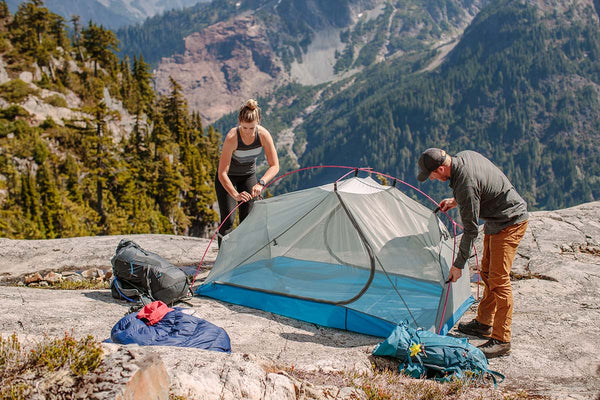
The Zion 2P Backpacking Tent is lightweight and gives you some privacy along the Oregon Coast Trail.
For your sleep system, a lightweight down quilt will be perfect. It saves on weight in your pack and functions just as well as a sleeping bag. You'll also need a sleeping pad for extra comfort and insulation.
If you don't mind the extra few ounces, a sit pad is a nice addition to your load out. With so many beaches along this section, you can take a little break without getting your behind all sandy.
Though the terrain isn't too demanding, you might still bring some lightweight trekking poles. These can help you get through soggy parts and water crossings.
If there's anything else you need to complete your pack, visit our full line of high-quality, affordable backpacking gear.
Shop Backpacking Tents
Shop Ultralight Tarps
Shop Backpacking Quilts
Shop Down Sleeping Bags
Shop Insulated Sleeping Pads
Shop Backpacking Pillow
Shop Folding Trekking Poles
Shop Titanium Cookware
Shop Tent and Tarp Accessories
Finally, to make sure you don't forget something at home, use our Ultimate Backpacker's Packing List. It even includes a convenient printable checklist!
Do I Need a Permit?
No permits are needed to hike the Oregon Coast Trail.
Resources
Conclusion
If you don't have time to complete the entire Oregon Coast Trail, Section 1 is a must-see. Have you completed any of the OCT? Which are your favorite sections? We'd love to hear about them in the comments below!
Read Next
If you're looking for more hike ideas, read our “Top 10 Best Backpacking Trips in Washington State” round-up post. Also, the following Hike of the Week articles cover other great trails in the region.
Hike of the Week: Timberline Trail
Hike of the Week: Three Sisters Loop
Hike of the Loop: Rogue River Trail
For even more amazing backpacking trips visit The Trailhead, our interactive hike map. It contains a curated list of dozens of hikes, each with a detailed write-up like this one.

Finally, check out our comprehensive list of backpacking articles that cover just about everything there is to know about backpacking. If you're just starting out, our Backpacking 101 section covers all the basics. If you already have a few trips under your belt, you can find more advanced topics covered in our Expert Articles.


Leave a comment